Lidar
- Former user (Deleted)
Intro
Lidar (Light Detection and Ranging) is used to determine distances of nearby objects and map the surrounding area in 3D. It sends out pulsed light waves which bounce off objects and return to the sensor. based off of the time it took for a light signal to return to the sensor, it can estimate distance using this equation:
The distance of the object=(Speed of Light x Time of Flight)/ 2

When Spinning the Lidar sensor 360 degrees, Lidar can map the surrounding area to show distances of objects and obstacles

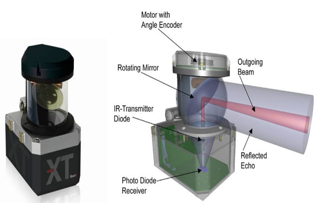
Parts of LiDAR sensor:
- Laser: used to send a light pulse. Better target resolution is achieved with shorter laser pulses.
- Phased Array: can illuminate any direction by using a microscopic array of individual antennas. Controlling the timing (phase) of each antenna steers a cohesive signal in a specific direction.
- Microelectromechanical Mirrors: A single laser is directed to a single mirror that can be reoriented to view any part of the target field. The mirror spins at a rapid rate.
- Sensor: photodetector to retrieve the rebounding laser signal.
LiDAR Uses
- Mapping: Surveying tasks often require LiDAR systems to collect three-dimensional measurements. They can create digital terrain (DTM) and digital elevation models (DEMs) of specific landscapes.
- Architecture: Laser scanning systems are popular for surveying the built environment too. This covers buildings, road networks, and railways.
- Real Estate: Laser scanners can be used indoors to measure space and create accurate floorplans.
- Construction: The construction industry is also using LiDAR surveys increasingly. LiDAR technology tracks building projects and produces digital twins for BIM applications. It can also help produce 3D models for the conditional monitoring of structures, and revit models for architects and structural engineers.
- The Environment: Environmental applications for LiDAR are plentiful. Laser scanning is a popular method of mapping flood risk, carbon stocks in forestry, and monitoring coastal erosion.
- Automotive: LiDAR is also seeing increased levels of adoption for automation applications. Smaller, low-range LiDAR scanners help navigate autonomous vehicles.
- Space Travel: If that wasn’t enough, LiDAR data isn’t only useful on earth! It has been identified by NASA as key in enabling them to land lunar vehicles safely.
LiDAR Advantages and Disadvantages
Advantages
- Data can be collected quickly and with high accuracy
- Surface data has a higher sample density
- Capable of collecting elevation data in a dense forest
- Can be used day and night
Does not have any geometry distortions
It can be integrated with other data sources
- It has minimum human dependence
- It is not affected by extreme weather
- Can be used to map inaccessible and featureless areas
Disadvantages
High operating costs in some applications
Ineffective during heavy rain or low hanging clouds
Degraded at high sun angles and reflections
Very large datasets that are difficult to interpret
- No International protocols
- Elevation errors due to inability to penetrate very dense forests
- The laser beams may affect the human eye in cases where the beam is powerful
- Inability to penetrate thick vegetation
Affordable LiDAR Systems
EAI YDLIDARX4: 2D Spinning Lidar. 10m max range. 80 USD
EAI YDLIDAR TX20: 2D Spinning Lidar. 20m max range. 180 USD
LIDAR-Lite v3: 1D Lidar. 40m max range. 130 USD
Benewake TFmini Plus: 1D lidar, 12m max range, 45 USD